Geophysical surveys are essential tools in the field of geotechnical engineering and environmental assessment. By employing non-invasive techniques such as seismic, resistivity, and electromagnetic methods, allows investigating subsurface properties without the need for extensive drilling or excavation. This approach not only minimizes disturbance to the site but also enables the efficient collection of large volume of data with minimum time frame to ascertain the geological formations, soil composition, and potential subsurface hazards.
The insights gained from geophysical surveys are invaluable for various applications, including site characterization, mineral exploration, and environmental monitoring. By understanding the subsurface conditions, Engineers and Project Managers can make important decisions regarding site development, resource extraction, and construction methods. Our geophysical team of experts is dedicated to delivering high-quality geophysical survey services, ensuring that your projects are supported by reliable and accurate data.

A seismic refraction survey is a geophysical method used to analyze subsurface geological structures by measuring the travel times of seismic waves. In this technique, seismic waves generated by a controlled source such as a hammer strike or a small explosive charge propagate through the ground and are refracted at the boundaries between different materials, such as soil and rock. Sensors, or geophones, placed on the surface record the arrival times of these waves, allowing for the determination of subsurface layer depths and properties.
This survey method is particularly effective for characterizing the subsurface conditions in a variety of applications, including site investigations for construction, groundwater studies, and environmental assessments. By providing detailed information about material properties and layering, seismic refraction surveys help engineers and geologists make informed decisions regarding foundation design, site safety, and resource management.
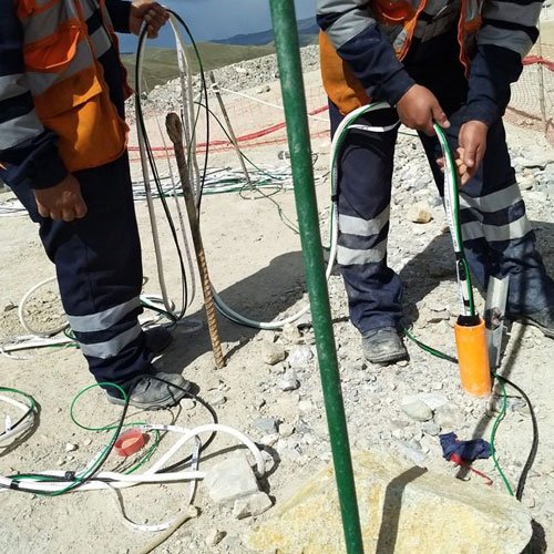
Cross hole seismic survey is used to directly measure the compression velocities, shear wave velocities, or both, in boreholes advanced through soil or rock. In this method, a borehole seismic source is used to generate seismic energy at selected depths of the borehole. The arrival of seismic wave is detected in the offset boreholes by a receiver kept at similar depths. The borehole seismic source is connected to a Seismograph that records the response of the down hole receiver(s). The travel time of the seismic wave between the source and receiver boreholes is measured.
The compression and shear wave velocity is calculated from the measured distance between boreholes and the travel time of the respective wave forms. The measurements are used to provide information pertinent to determine seismic wave velocities of the materials with hidden layer velocity anomalies in between two high velocity layers that cannot be detected with conventional surface seismic methods. The data is further used for various static and dynamic analyses, such as determination of Shear Modulus, Young’s Modulus and Poisson’s Ratio, or simply for finding out anomalies existing between boreholes.
Cross hole seismic survey method as per ASTM
Coupling detailed site information obtained from the crosshole tests with the overall acceptance of the validity of the velocity data, it is used for empirical correlations for liquefaction and specific input parameters for deformation or ground motion analyses study in Civil Engineering.


Downhole seismic survey, on the other hand, involves measuring Shear wave velocities directly within a single borehole, providing insights into the vertical variation of subsurface materials. These tests help determine important subsurface parameters such as soil stiffness and seismic shear wave velocities, which are critical for foundation design, earthquake engineering, and overall site characterization in construction projects
In civil engineering evaluation of foundation depth of existing structures, such as buildings and bridges, for which neither drawings nor as-built records are available is a frequent problem. Such situations happen when the foundation loads need to be increased or when it is intended to excavate near, or even under, the structure. In the case when the top of the foundation is inaccessible, Parallel Seismic method can be used to determine the deep foundation depth.
Parallel Seismic testing provides information regarding the length and compressional Wave velocity of foundations and can be used in concrete, wood, masonry, and steel foundations. PS Method is also useful to evaluate the compression wave velocity of soil below the foundation bottom.
The objective of the PS test is the determination of the unknown depth of a pile foundation or deep structures. PS data acquisition requires a borehole positioned very close to the foundation to be investigated to provide more accurate and reliable results.


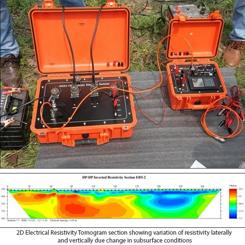
2D Electrical Resistivity Tomography (ERT) is a powerful geophysical technique used to create detailed images of subsurface structures by measuring electrical resistance variations in the ground. This method involves placing electrodes along the surface to inject electrical current and recording the resulting voltage measurements. The data collected allows for the mapping of different geological materials, including soil, rock, and groundwater, based on their resistivity characteristics.
ERT is widely utilized in environmental studies, engineering assessments, and resource exploration, providing valuable insights for construction projects, groundwater management, and contamination investigations. Its non-invasive nature makes it an efficient tool for subsurface analysis.
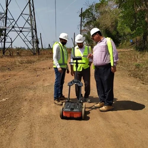
Ground-Penetrating Radar (GPR) survey is a non-invasive geophysical method that utilizes radar pulses to image the subsurface. By transmitting high-frequency electromagnetic waves into the ground, GPR detects reflections from subsurface structures and materials, providing real-time data on geological formations. This technique is particularly effective for mapping the thickness of layers, locating utilities, identifying voids, and detecting buried objects, making it invaluable in various fields such as construction, archaeology, and environmental assessments.
The data collected from a GPR survey is processed and visualized to produce detailed images of subsurface conditions with voids and underground utilities. These insights are quite useful in taking decisions regarding site development and potential hazards. GPR is a non-invasive technique without disruption to the site evaluates accurate and comprehensive subsurface information, enhancing the safety and efficiency of construction and investigation projects.

- To determine the variation of seismic velocities Vp, and resistivity “ρ” vertically and laterally with to a depth up to 120m depth from the ground surface as per client requirement and availability of ground space.
- To determine the variation in shear wave velocity (Vs) with depth and calculation of harmonic shear wave velocity (Vs30) up to a depth of 60m for site classification for earthquake proven design parameter and site specific response study.
- To determine the overburden soil stiffness with thickness of different subsurface layers.
- To delineate the weak zones within the subsurface along the profile if any.
- To determine ground water table and saturated zones within the depth of investigation.
- Assessment of engineering properties of rock mass viz., Density, Poison ratio, Modulus of Elasticity, Shear Modulus.
- Assessment of ‘Q” RMR, Intact rock mass strength (σc) and Rock mass classification (RMC) for tunnel support design and excavation method.
- Based on SRT and ERT studies mapping of subsurface stratigraphy with the ground water saturated zone within the probing depth.
- Interpretation of geophysical data for Geological inferences with presentation of geological sections. Based on the inferences, identification of exploratory drilling locations for confirmation of geophysical investigation.
- Low cost of operation
- Rapid assessment of reliable sub surface information
- Project planning & cost estimation
- Less time for acquiring large volume of data.
- Methods are non-destructive in nature.
- Accessibility to remote region
- Data acquisition :
- Instrument resolution & Accuracy
- Survey Procedure & data quality
- Adequacy of Data
- Data analysis :
- Reliability of survey data
- Data Consistency
- Interpretation:
- Correlation and study of interrelation between physical properties of subsurface material like velocities & resistivity, density etc. with lithological and structural features.
IGS Geotechnical services Equipped with latest State-of the-Art Geophysical instrumentation with advanced software for data processing and interpretations with team of expert Geophysicists. The team of Geophysicists is having vast experience and knowledge on the domain to provide the best economical solution to any Geotechnical Problem either on land or in water.
IGS Geotechnical services have carried out Geotechnical Investigations including Geophysical investigations for a number of prestigious projects in the country and has attained the outstanding status of being the organization that provides total consultancy for complete Geotechnical & Geophysical investigations.

